
To complete our listing of sites that have been suggested for development, here’s what we’ve seen for the eastern part of the district.
Just to repeat what we said previously – these are sites that landowners and developers have suggested could be used for housing. The District Council has not considered them yet. At this stage we are not saying whether any proposal is ‘good’ or ‘bad’.
Ashingdon
Land adjacent to Avoca Lodge, The Chase – 0.3 hectares
Land off Rectory Avenue – 4 hectares
Land at Rectory Farm, (mixed use, residential open space and employment) – 57 hectares
Land at Brays Lane – 2.2 hectares
Land east of Highcliff Crescent – 1.9 hectares
3 small sites on the south side of Canewdon View Road – 2.2 hectares
Land South of King Georges Field – 6 hectares
Barling
Land in Little Wakering Road, adjacent to the primary school – 2 acres
Land at 36 Barling lane – 0.2 hectares
Canewdon
Land at Three Acres and Birch Lodge, Anchor Lane – 1 hectare
Land at Crouch View, Larkhill Road – 4 acres
Great Stambridge
Land at Stambridge Road – Residential with Public Open Space – 9 hectares
Great Wakering
Land south of the High Street. ( Residential/ Mixed use) 8 hectares
Land at Tithe Barn Farm 33 hectares
Land at Shoebury Road – 7 hectares
Land at Shoebury Road/ New Road – 14.5 hectares
Land at Star Lane – residential or mixed use – 3.3 hectares
Paglesham
Land adjacent to Cobblers Row – very small , 0.048 hectares
Rochford
Land at “Peggle Meadow’ , rear of 193 Southend Road 3.7 hectares
Land South of Stambridge Road – 12 hectares
4 sites NE of Rochford Town Centre 54 hectares
Watts Lane – (residential or mixed use ) 1.9 hectares
Land at Pelhams Farm – 0.6 hectares
Sutton
Land at Temple Farm – mixed use residential and employment – 54 hectares
The plan now out for consultation suggests:
1000 homes for Rochford and Ashingdon combined – this would need maybe 20-33 hectares.
500 homes for Hullbridge, Canewdon and Great Wakering combined – this would need maybe 10- 17 hectares.
No significant housing in the smaller villages
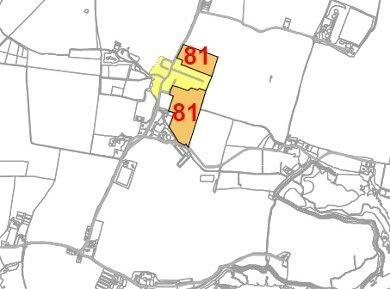
UPDATE: Here is a small map showing the location of the possible site in Stambridge Road:

Does anyone know where abouts on the stambridge road the new houses are proposed to be built?
Emma – sorry for not replying before.
The landowners are suggesting 9 hectares of “Residential with public open space”.
If you can download the map at:
http://www.rochford.gov.uk/rdc/PDF/planning_sites_east_district.pdf
you will see it is ‘site no 81.’
But just to help, I going to copy the bit around ‘site no 81’ and put it just above the comments here.
Hope that helps a bit, but please ask if there is anything else we can help with.