The District Council thinks “West Rochford” should be another big location for housing – 600 new homes, in two phases.
The people who live in the homes on the south side of Hall Road are most likely to be affected.
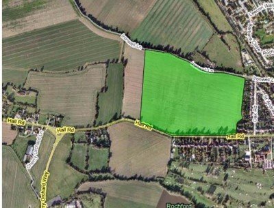
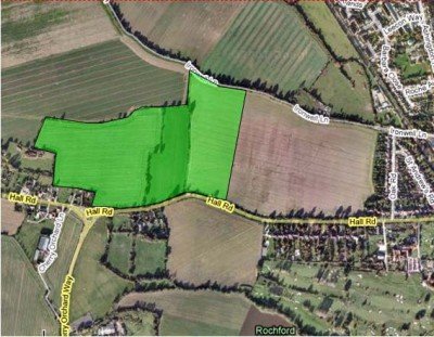
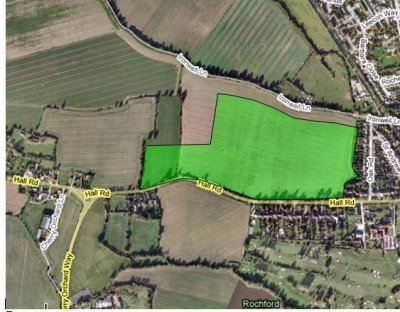
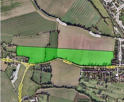
The district council officers have come up with 4 options:
(The green area is for “Residential, incorporating provision for education, public open space, youth and community facilities and play space”)

The council document says:
Option WR1 is north of Hall Road and adjoins existing residential areas to the
south and east. West and north of the site are agricultural fields and the site
itself is currently used for agriculture purposes. The site is not subject to
significant constraints that would restrict development, other than a small area
in the north-east corner which is within flood zone 2.
It is within walking distance of Rochford Train Station, which provides a direct
link to London Liverpool Street and Southend Victoria stations. The site is
also close to bus links and Rochford town centre. The site is large enough to
support the required number of dwellings from this location, and would be able
to provide the community benefits as stipulated within the Core Strategy
Submission Document.
The site adjoins existing residential areas and thus has the potential to
integrate with the existing community. The infrastructure that could be
delivered within the site has the potential to benefit the wider community. The
Core Strategy Submission Document requires the following infrastructure to
be implemented in developing in this location: local highway capacity and
infrastructure improvements, public transport service and infrastructure
improvements, Sustainable Urban Drainage Systems, and links and
enhancements to local pedestrian, cycle and bridleway networks. This site
has the potential to incorporate all of these, whilst also providing a defensible
Green Belt boundary.

“Option WR2 is north of Hall Road and Cherry Orchard Way. Rochford Train
Station is to the south east of the site which is within walking distance. East
and north of the site lie agricultural fields, and west of the site are several
residential dwellings. The site is detached from the residential area of
Rochford, although the town centre is within walking distance. Separation
from the community of Rochford may result in two distinct communities and
community isolation as a consequence. The capacity of the site gives an
appropriate contribution to housing targets. The site is in a sustainable
location close to train station, bus links, and town centre, with suitable
highways access.
The Core Strategy Submission Document states that the
following infrastructure will be required alongside this site: local highway
capacity and infrastructure improvements, public transport service and
infrastructure improvements, Sustainable Urban Drainage Systems, and links
and enhancements to local pedestrian, cycle and bridleway networks.
Benefits to the existing community from this site would be harder to access
due to its location away from the existing settlement. The site would not
afford a good opportunity for the creation of a strong defensible green belt
boundary.”

“Option WR3 is as WR1 except this site extends further west, and does not
extend as far as Ironwell Lane to the north. Still within walking distance to the
town centre, bus stops and Rochford train station the location of this site
would enable a green buffer around the northern and western perimeter of the
site. The site is adjacent to the current residential settlement to the east of
Rochford, and thus the community would be able to see the benefits obtained
from this development, and the new community would not be segregated in
any way. Community cohesion would also be more achievable with this
location due to its proximity to the existing settlement. However the northern
edge of the site will not provide a defensible green belt boundary.”

“Option WR4 is as WR1 except the site extends further west to the settlement
opposite Cherry Orchard Lane and does not extend as far north as Ironwell
Lane. To the south of site is Hall Road and to the south east lies Rochford
Train Station which is within walking distance. East of the site lies the train line
and west and north of the site lie agricultural fields.
Ribbon development is not encouraged as this is considered to be not as sustainable, and in
this case would result in dwellings to the furthest north west point of the site being
removed from the existing community, and having to travel a lot further to
reach the town centre, train station and associated services. Again, this site
will not provide a natural defensible green belt boundary.”
First thoughts ? The last three options don’t have “defensible Green Belt boundaries” (that means they would leave isolated bits of farmland to be swallowed up for further development) .

There is a West Rochford Action Group which has been running since last year. But my guess is that they won’t like any of these !! http://wrags.org/
These sites are very close to the site at Hawkwell, so a total of 775/900 homes in close proximatey, plus those at the other end of Rectory Road. So may be 2,000 extra cars on the local roads, plus unknown extra airport traffic.
As far as I am aware, the only road improvement proposed by RDC is to dual Cherry Orchard Lane…..but what happens when all the extra traffic reaches the B1013?
Hi Brian
I understand and recognise the point that you are raising and it is not just about Hawkwell but the whole District. As you know, I have already made a strong representation to the Planning Inspector, Laura Graham, that she include this concern in the Schedule of Matters and Issues that will set out the subjects to be discussed at the Hearings.
I am hoping that other organisations such as your Hockley Residents’ Association, Lib Dem Group and Rawreth Parish Council as readers of this site will also now write to the Planning Inspector, via the Programme Officer at RDC, to press the case to see this included hence this long and detailed posting. [I hope that Chris and Ron don’t mind this approach.]
As a draft of this paper will be made available at the Pre-Hearing Meeting on 24 March we will know pretty soon whether this is to be ignored or not. My current view is that it will not be included unless more organisations of influence raise the issue. But I would like let residents to know that I have personally, as a district councillor, tried my dammedness to raise this on behalf of the whole district (and not just my Ward of Hawkwell West).
My stance is as follows:
My evidence is that ECC have raised this issue and whilst RDC has responded I feel that the basis and content of the RDC argument against the concern does not fulfil a SOUND position in response to ECC concern.
Here is the evidence; tell me if you disagree because it might save me a lot of grief fighting with the Planning Inspector if I am wrong.
RDC Consultation Statement at Submission of Core Strategy for Rochford District
Appendix 3 – Summary of issues raised Pre-Submission consultation and initial officer comments
Page 169 – Issue raised by Essex County Council as Highways Authority
http://www.rochford.gov.uk/PDF/planning_cs_consultation_statement.pdf
RDC Response
It is time for some alternative thinking, ideas and views. This juggernaut that is the East of England Plan, Development Framework, whatever, has been rumbling along and is now gaining pace. We do not have to have large scale developments, this is what that developers want as they will have economies of scale and it will boost their profits. What has been a success in other parts of the country is small sustainable plots and the the use of empty homes. Why not use these options first before bowing to the developers, its not as if the developers give much back to the community and when they do, we do not use these funds in the timescale given.
The Government need to look at other ways of development. They do not even look at the infrastructure, I suppose they thought it a good idea ‘at the time’, well its not and the sooner the Government, Inspectors, Town Planners and our own RDC look beyond their noses the more they will see that this is a flawed plan. The Kings new clothes come to mind here.
God help us all.