We’ve already written a lot about the District Council’s “Core Strategy” . That’s the master plan for future development into the 2020s , including:
550 homes ‘North of London Road’ (plus 220 on Rawreth Industrial Estate) – between 2015 and 2021
600 homes in ‘West Rochford’ (plus more at Stambridge Mills) – between now and 2021
50 homes in ‘West Hockley’ 9 (plus more on the Eldon Way Industrial Estate) – before 2015
175 homes in “South Hawkwell” – before 2015
100 homes in “East Ashingdon” – before 2015
500 homes in “South West Hullbridge” – from 2015 onwards into the 2020s
60 homes in “South Canewdon” – between 2015 and 2021
500 homes in “South East Ashingdon” – after 2021
250 homes in “West Great Wakering” (Plus more at the Star Lane Industrial Estate)- after 2021
The council has now produced its discussion documents for exactly where this housing and other development would go.
You can download them from this webpage.
For example, for “Land North of London Road” it sets out 5 options. We show below the maps from the council document, together with the council’s own descriptions. The green areas on the maps are for “Residential, incorporating provision for education, public open
space, youth and community facilities and play space”. (We will be writing about other areas and other issues in other pieces on onlinefocus – there’s far too much to include in one item here.)
The options for land “North of London Road” are:
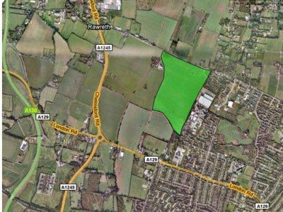
“Option NLR1
The site lies directly south of Rawreth Lane, and is adjacent to the residential
settlement to the east. Consideration must be given to the area of land to the
south of the site that lies within Flood Zone 3, as this land will be required to
accommodate non vulnerable uses.”
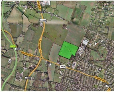
“Option NLR2
Option NLR2 is as per NLR1 except the site is further south of Rawreth Lane,
and thus closer to London Road. Access to this site would be via London
Road or the surrounding residential development. Consideration must be
given to the section of the land through the centre of the site that lies within
Flood Zone 3; this land will be needed to accommodate non-vulnerable uses.
The site would afford opportunities for the creation of a strong defensible
green belt boundary.”
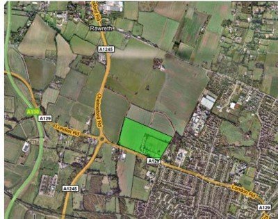
“Option NLR3 is as NLR1 and NLR2 but directly north of the London Road.
There are few pylons on this area, and the area is again adjacent to
residential areas. The site would offer excellent access to the A129 and
A1245, and thus the surrounding main routes. The site would afford
opportunities for the creation of a strong defensible green belt boundary.”
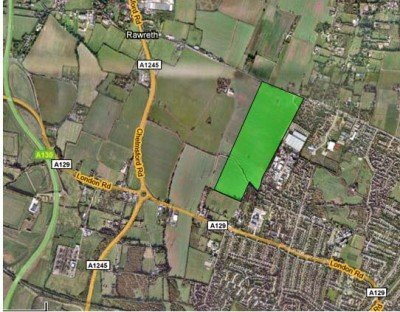
“Option NLR4 is as NLR1 but extends from Rawreth Lane south to just north
of London Road. This location would enable community cohesion due to its
location adjacent to existing residential settlement. The site is also well
situated in relation to town centre services and facilities and the transport
network. Consideration must be given to the section of the site to the south
which lies within Flood Zone 3; this will be required to accommodate non vulnerable
uses. The site would afford opportunities for the creation of a
defensible green belt boundary.”
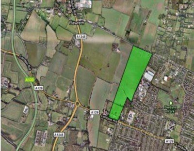
“Option NLR5 is as NLR4 except this site extends further south to London
Road. This location would enable community cohesion due to its location
adjacent to existing residential settlement. The site is also well situated in
relation to town centre services and facilities and the transport network.
Consideration must be given to the section of the site to the south which lies
within Flood Zone 3; this will be required to accommodate non-vulnerable
uses. This site would also enable the implementation of a bus only through
route from Rawreth Lane to London Road, into Rayleigh centre. The site
would afford good opportunities for the creation of a strong defensible green
belt boundary.”
Here’s some initial thoughts on these:

Admin, the land off the A129, is some of this land owned by the Councillor who wants to sell to developers? The land off the A129 with “good links to the A1245”. The A1245 is gridlocked NOW, can you imagine what it will be like when there are all those new houses with the obvious extra traffic all wanting to get onto the A127. This is a recipe for a nighmare. How do these planners think we are going to absorb all this extra traffic? It will be a nightmare but of course if the Council and the inspectors say yes, that is it and we have to put up. Well I think we should enlighten the inspectors and let them know exactly how we feel!!
As far as I know , none of the land up for development is owned by a councillor. One councillor’s family farms many acres in the district, but I don’t know what land they actually own and have seen no evidence that there have been any breaches of the council code of conduct regarding declaring interests.
Why do they persist with comments about forming a “defensible greenbelt boundary”, when this whole project is based upon them ripping up the existing greenbelt boundaries. Are we to believe the new boundaries will provide any more defence than the current ones?
Some of these options seem to vary considerably in area, I take it the proposal is to maintain the number of new houses but change the density? Or will they change the amount of open/shared/park space?
Echoing Mike comments about additional traffic, although I welcome the consideration of the A129 instead of Rawreth Lane as an alternative for access, neither road really has any excess capacity, and in reality, if one of these two roads becomes choked with traffic, so does the other one as drivers seek an alternative route. Watery Lane will also take a hit as well, and on top of this there are the added houses “South West of Hullbridge” to consider as well, as well as the added traffic for any developments in Hockley etc.. Tuesday before last was an excellent example, 25 minutes to drive from Downhall Park Way, along Rawwreth Lane/A1245/A129 to Sweyne school at 6 in the evening.
I also don’t agree this site is “well situated in relation to town centre services”. This location is a long walk from Rayleigh town centre, and WILL increase car journeys into town and/or encourage new residents to use out of town facilities rather than support the town economy.
Can anyone shed any light on this comment contained in the proposals:
“Consideration must be given to the section of the site to the south which lies within Flood Zone 3; this will be required to accommodate non-vulnerable uses.”
ST1
– the current green belt boundaries are defensible,in that you, me or a planning expert can stand up at public enquiry and say that the current boundaries are sensible in planning terms and don’t leave any pockets of green belt ready to be gobbled up.
And some of the proposed new boundaries could be defended again in 10 or 20 years time – eg NLR5, or WR1. But others such as NLR1 and WR3 are literally not defensible.
– the non-vulnerable uses would be non-residential uses, maybe open space or buildings that wouldn’t suffer too much if flooded.
Mike at 1: – . Yes, these proposals would obviously make traffic worse. Rawreth Parish Council supports an alternative of having some housing built on the A1245 to the north of the Rawreth Lane junction in the centre of the parish. At least commuters who lived there would be be likley to use Battlesbridge rather than Rayleigh Station….
On the bright side, at least we’ve got the figure reduced from 1800. And we have to make sure that nobody tries to increase it again!
That is the plus point Chris, what we have to ensure is that these houses are built in the right places. The issue of infrastructure should play a key role in where they are built. I have ‘nightmares’ of how gridlocked the 129, 1245 and 127 will become when all these houses are built and we have to contend with the increase in traffic, summers will be for staying at home and not venturing out on to the roads! At least we will all be fitter for having to walk everywhere. Maybe the increased cost of buying petrol will price people out of using their cars?
surely before planners agree to huge numbers of new builds a comprehensive count could be made of all the empty properties throughout the county. People are quite happy to divulge such information if they live next door to one these valuable waste of resources. Government buildings of any description seem to be amongst the worst offenders, look along Victoria Ave, SOS. The proliferation of empty 1 bed flats, how about ‘inducements’ to developers holding these to knock them into 2 beds with then enough living space for a small family. Its time to start thinking outside the box and to protect our greenbelt for our grandchildren and beyond. We can see from the above proposals that Brownfield sites are viable when enough profit is involved.
Carole, Couldn’t agree with you more, but the powers that be (and the developers)are not interested in sensible and green proposals!
Chris, do we know where, exactly, north of London Road is? Because I dont.
Mike, “North of London Road” presumably means anywhere between London Road and Rawreth Lane, but the council are suggesting 5 locations as above.
Here we go again, a third request for comments on the Rochford District Local Development Framework, using the difficult and time consuming method required when using the RDC’s web site format.
· First we had the LDF document, then the Preferred Options doc. and now,
· The Allocations Development Plan Document and
· The Development Management Development Plan Document (RDC,s use of Development twice not mine).
How many more times will we have to submit our views to get the points over?
Most of the time we are reiterating the same points over and over again!
It’s no wonder that people become frustrated and drop out of commenting, not to mention the thousands, if not millions, of pounds the whole process is eating up.
In the end, RDC will get their preferred options because they have our money to throw at the project and the resources to overcome most of what we, the public have to say.
It’s a ‘done deal’! Are we wasting our time?
Greenebelt, I sympathise with having to go through the loopm yet another time on a council consultation.
But we are not wasting our time.
Few organisations like to admit they are wrong, or taht they are changing tack, but we are winning….
We’ve already got the figure for Rayleigh / Rawreth reduced from the original 1800 (which would actually have been 1800 + 220 on the Rawreth Industrial state).
Now it’s 550 + 220. That still left a lot of concern – especially that once the council encroached on that huge square of farmland, there would be no natural stopping point until develoeprs reached the A1245. Plus issues of traffic and drainage/ flooding.
Now we’ve got the council offering 5 options, and admiting that the one that encroaches most ominously onto farmland doesn’t give a future defendable boundary.