It’s not had much fanfair, but the District Council’s response to their consultation in 2010 (yes, 2010!) on future development was published last month.
It’s the “Summary of Consultations and Sustainability Appraisal Report”. You can download it from this page – it’s a hefty 5.47 Mb.
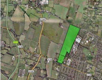
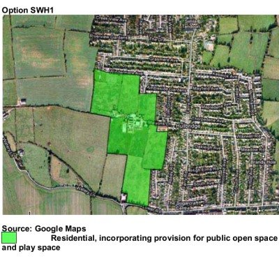
There are no decisions here, but some definite indications of district council thinking. The Council has already decided it wants to build on “London North of London Road” and South West Hullbridge”. Now we can see which locations come out best in officer thinking. They seem to be “NLR5” and “SWH1”


The key points they make regarding NLR5 are :
Here are their arguments in full:
6.5 Option NLR5 would have less of an impact on the landscape character of the area as
opposed to the other options for this general location as it does not extend as far west
from the existing residential development of Rayleigh. It would ensure greater
accessibility than Option NLR2 in particular and it would also enable the provision of a
public transport link between Rawreth Lane and London Road, connecting this area to
the west of Rayleigh with the town centre. This public transport link would enhance the
sustainability and accessibility of communities and services in this area.
6.6 Cohesive development in this general location, however, would depend upon the
reallocation and redevelopment of Rawreth Industrial Estate which is situated to the
east of most of the options, with the exception of Option NLR3, for residential use.
6.7 The area at risk of flooding in this general location impacts on the capacity of some of
the options to accommodate the infrastructure to support development, in particular
Option NLR2. Any areas at risk of flooding must accommodate public open space
(which is water-compatible development in accordance with national planning
guidance). The inclusion of public open space would have a negative impact on
community cohesion if Option NLR2 was brought forward for development through
severing the developable area of the site. Nevertheless a range of sustainable
drainage systems (SUDs) are available to manage excess surface water in the area.Recommendations/Key Observations:
(1) Option NLR5 performs strongly against the sustainability objectives and would
enable to development of a pubic transport link between Rawreth Lane and
London Road.
(2) The impact of areas at risk of flooding on the siting of residential development
would need to be carefully considered, but residential development can be
accommodated whilst avoiding such areas.
(3) The existing playing field to the south of the site is an established community
facility which should be retained.
Regarding education, there’s a tacit acceptance that a new primary school may not be needed in West Rayleigh after all and could be a waste of money:
Site North of London Road Rayleigh
6.155 The sustainability of allocating a single-form entry primary school to the north of
London Road, Rayleigh depends on the specific site allocated for residential
development. Please refer to the Sustainability Appraisals for residential development
in this general location (Options NLR1 to NLR5).
Regarding “South West Hullbridge”, it says:
6.29 Although none of these options are situated within immediate proximity to any areas
designated for their ecological importance, Options SWH1, SWH2 and SWH3 are
situated within the Coastal Protection Belt (Option SWH3 to the greatest extent). The
Coastal Protection Belt is, however, a landscape quality designation rather than an
indication of ecological value. Whilst Option SWH4 avoids this designation, the area
directly north of this option is existing residential development and so would expose
the field to the north of Malyons Farm (which is designated Coastal Protection Belt) to
development pressure. Consequently the exclusion of the land to the north may
weaken the defensibility of Green Belt boundaries in the locality and undermine the
openness of the Green Belt on a wider scale.
6.30 Options SWH1 and SWH2 are well related to the existing residential area and the
local services and facilities situated within the village centre along Ferry Road. These
options have good links with the local highway network through existing minor roads
to the east and Lower Road to the south. However, it is recommended that for these
options, and the other options, pedestrian links to the east are provided rather than
road connections to prevent a possible negative impact on the village?s existing
highway network, and to encourage more sustainable transport to the village?s
services. When compared to Options SWH1, SWH2 and SWH3, however, there are
fewer opportunities for Option SWH4 to provide pedestrian routes to the shops and
facilities along Ferry Road. Furthermore whilst Option SWH4 has good links with the
existing settlement, the severance between the sites may impact on community
cohesion.
6.31 Option SWH3 does not have a good relationship with the existing settlement
compared to Options SWH1 and SWH2. Local services and facilities may be less
accessible for those in the community without access to private transport as Option
SWH3 extends further away from the village centre (Ferry Road is situated to the
east). The existing bus route, providing access to Rayleigh town centre to the south,
may be less accessible for some as the option extends further to the north west than
Options SWH1 and SWH2. Option SWH3 also does not connect to Lower Road, as
opposed to the other options, which may further limit equal opportunities for the
population in terms of access to services and facilities. This option would potentially
require a new road link outside of the site which would further encroach into the Green
Belt, however, pedestrian links for the existing minor roads to the east would be
recommended.
6.32 In terms of landscape character, Option SWH2 is likely to have a greater impact than
Option SWH1 as it extends further to the west than this option, past the junction of
Lower Road, Watery Lane and Hullbridge Road, but the northern section does not
extend as far to the west. The projection of Option SWH2 further to the west would
potentially have a greater visual impact in the locality from the roads to the south
compared to Option SWH1. However, it would still be better placed to provide a
defensible Green Belt boundary than Options SWH3 and SWH4. Indeed, the
arrangement of Option SWH3 would leave the area to the south undeveloped, which
may weaken the Green Belt boundaries in the locality and undermine the openness of
the Green Belt on a wider scale. Similarly, as mentioned above, Option SWH4 does
not extend as far northwards as Options SWH1 and SWH2 which would expose the
area to development pressure.
6.33 Although there is an area at risk of flooding to the west of this general location, the
options are not within flood zone 2 or 3. The boundary of Option SWH3, however, is
particularly close to this area. A range of sustainable drainage systems (SUDs) are
available which can be used to manage excess surface water.
Recommendations/Key Observations
(1) Option SWH2 performs well against the sustainability objectives, but Option
SWH1 performs even stronger.
(2) Options SWH1 and SWH2 are well related to the existing residential area and
the local services and facilities situated within the village centre along Ferry
Road.
(3) Option SWH2 may have a greater impact on landscape character than Option
SWH1 in terms its projection further to the west, which would potentially have a
greater visual impact in the locality from the roads to the south.
(4) Pedestrian links to the east should be provided between the option taken
forward and existing residential development rather than road connections to
prevent an overburden on the village?s existing highway network.
Incidentally, according to a piece we wrote on Onlinefocus back in August 2010, regarding Land north of London Road, Rayleigh there were 203 responses regarding the general location. None in favour, 7 comments , 196 objections.
For South West Hullbridge, there were 891 responses regarding the general location. 4 in favour 20, comments, 867 objections.
We”ll be looking at other locations in the district later…..
