
What’s this all about? Well, this is the Strategic Housing and Employment Land Availability Assessment (SHELAA) which will form part of the evidence in the new local plan. The issue of SHELAA will always, in my opinion, be contentious. It is worth noting that at this stage although the sites have been identified, it doesn’t mean that they will be approved for housing.
For Down Hall & Rawreth the sites are plentiful and we will be updating our residents on how to take part in the public consultation in the coming weeks. For now here is a map of the potential sites.

So in simply terms what does this mean. My guess would be areas for even more housing.
The ‘gold rush’ for landowners. Put your land forward and ‘hope’ it gets adopted in the local plan
Do the plans that were published for the improved roundabout at the east end of Rawreth Lane provide us with a hint of how this will go? The plan that had a “bonus” exit from the roundabout into the fields at Lubbards Farm….
That’s a good observation…
Amongst all the decoys there will be the ‘chosen ones’ that Mr Scrutton and Co have already targetted, one of which will be Lubbards Farm , WHY :-
The funding for the roundabout in question is’nt yet all found, the Malyons Site at Hullbridge is only contributing part funding,
ECC will not pay for it so another big site Developer is needed
to make up the contributions – simple !!!.
Unfortunately this will take time so the Hullbridge Site Construction traffic will be tolerated using the existing junction,
in fact the Malyon’s Site deal means they can build up to 50
homes before their contribution is even due , but Lubbards
contribution won’t be forthcoming at that point – so soldier on
without a roundabout ………
We’ve heard rumours that the numbers are being cut on housing in Hullbridge so I wonder if this will bring about a proportional S106 payment cut? They are only rumours though….
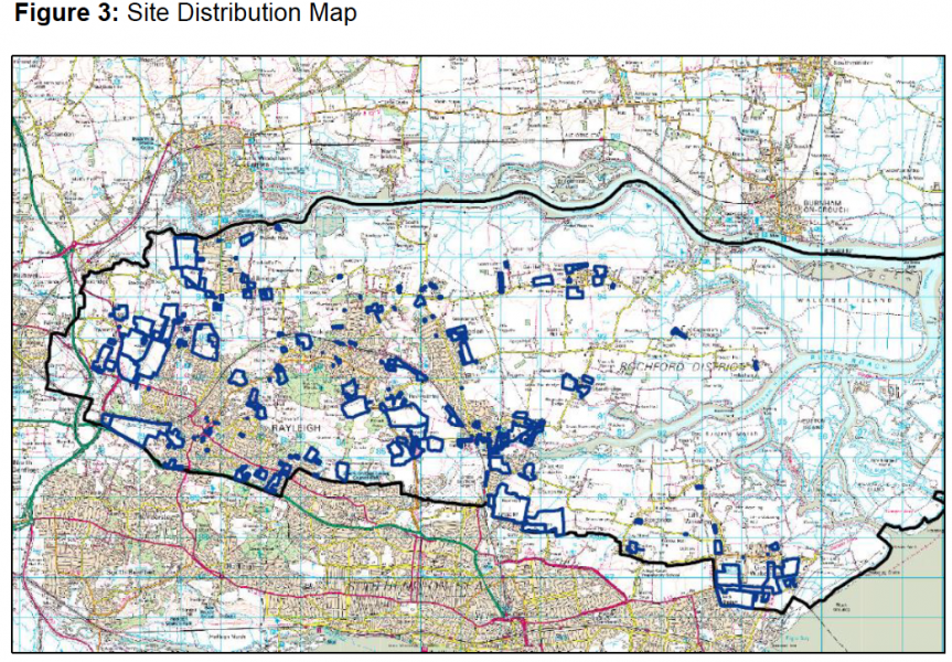
I’ve uploaded the site distribution map for the district
Thanks Admin , that overview map says it all –
Rayleigh – surrounded
Rawreth – concreted over
Hullbridge – doubled in size
Token small plots in Tory held outskirts
Actually this needs to go in the Echo and on FB – it is something the public can grasp at a glance…Jim.
PS: in fact this would be the ideal way to sum up the situation via a yellow flyer …….
Some STATS for you all – I have been once through the 1135 page call for sites document, the
Proposals distribution by Town is as follows :-
Rochford ( itself and all East of there ) – 98
Hawkwell – 15
Hockley – 23
Rayleigh 67
Hullbridge – 24
……………………… Rayleigh details :-
Town Centre – 9 ( inc main Car Parks !!! )
East of Town – 24 ( inc Eastwood )
West of Town – 34 ( inc Rawreth )
Obviously I am going to research the West , we need local knowledge for the impact on Central and East areas….anyone ?.
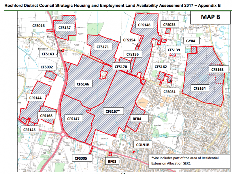
OK , I have now made a second pass of the document , concentrating on our own West Rayleigh / Rawreth , summary notes :-
It is actually 38 proposed sites, 3 of which are
pre-determined ( from Previous Local Plan ) ie
SER 1 Land North of the London Rd
NEL1/GT1 Michelin Farm ( Fairglen corner )
BFR4 Rawreth Ind Estate ( into residential use ).
Of the remaining 35 some 32 are currently classified as Green Belt status varying in size
from 0.02 through to 67.3 Hectares.
London Rd itself gets off relatively lightly this time,
a small plot opposite Lower Barn Farm and the
Car Sales place opposite the BP/ M&S garage,
whereas Rawreth Lane and Rawreth in general
would bear the brunt of large developments.
Too much to type here but if you look at the maps
to identify the CFS No , you can them skim through the 1135 page online document and read the RDC
1st appraisals ( which includes intended usage !! ).
Hope this helps….
Sorry , bit pre-occupied with Downhall & Rawreth, a couple of other West of Rayleigh surprise items –
Upper Hambro Hill area CFS105 , 10.3 Hectares,
Intended use -Residential , this is the site where the 6 car Transporter Lorries come & go, entry near the steep/blind bend.
Great Wheatley Rd area CFS077, 11.24 Hectares,
Residential / Mixed use? , currently Green Belt zoned – fields behind the big houses…….